- Researchers compiled data on over 1,300 water diversion sites.
- The database records daily water withdrawals from 1980 to 2022.
- It offers unprecedented detail on surface water use in the basin.
- This tool aids in managing one of the world’s most overallocated rivers.
November 25, 2024 — A team of scientists has unveiled a comprehensive database detailing over four decades of water diversions in the Upper Colorado River Basin. Published on November 21, 2024, in Scientific Data , this resource provides invaluable insights into how surface water has been used and managed from 1980 through 2022.
The Colorado River is a critical water source, supplying drinking water to 40 million people and irrigating 5,436,318 acres of farmland. Despite its importance, data on where and how much water is diverted has been scattered across various state and federal agencies, making it challenging for researchers and policymakers to access and analyze.
“Water withdrawals throughout the Colorado River Basin are primarily from surface water,” the researchers note , highlighting that in the Upper Basin, surface water diversions account for 98% of total withdrawals. Understanding these diversions is essential for managing the river’s resources, especially since the Colorado River is considered one of the most overallocated rivers globally.
Bridging the Data Gap.
The new database compiles information on 1,358 major diversion structures, such as canals and pipelines, capable of withdrawing over ten cubic feet per second of water. It includes daily time series withdrawal records, offering a fine-grained look at water use over 42 years.
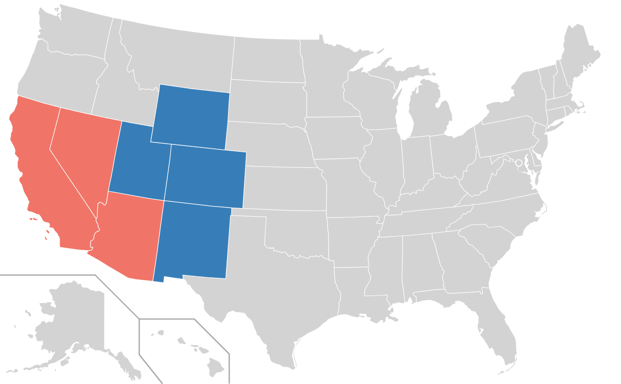
“Detailed spatial and temporal information on the diversion of surface water is crucial,” the authors state. By bringing together data from five states—Arizona, Colorado, New Mexico, Utah, and Wyoming—the database overcomes the challenges posed by the previously fragmented information.
Implications for Water Management.
With the Upper Colorado River Basin contributing an estimated 92% of the river’s natural streamflow, this database is a significant water management and planning tool. It supports efforts to evaluate water quantity and quality, assess human and ecosystem needs, and understand the impacts of human activities and climate change on water resources.
“Further characterization of diversion structures will greatly aid in assessments of water resources and water availability,” the study emphasizes. The database serves researchers and modelers and assists water use planners in making informed decisions in a region facing increasing water stress.
The creation of this centralized dataset marks a step toward sustainable water management in the Upper Colorado River Basin. The researchers hope to facilitate better planning and conservation efforts by providing open access to detailed diversion records.
As water scarcity becomes an ever-pressing issue, tools like this database are essential for ensuring that vital resources like the Colorado River can continue to support both human needs and ecological health for generations to come.
Citation.
Lopez, S.F., Knight, J.E., Tilman, F.D. et al. Database of surface water diversion sites and daily withdrawals for the Upper Colorado River Basin, 1980–2022. Sci Data 11, 1266 (2024). https://doi.org/10.1038/s41597-024-04123-0
Image.
Member states of the Colorado River Compact . Blue = Upper Basin; red = Lower Basin. By MarginalCost, April 2018. Licensed under the Creative Commons Attribution-Share Alike 4.0 International license.


Leave a Reply