- Statewide Airborne Electromagnetic (AEM) Survey Project is complete.
- Provides publicly accessible data to identify ideal groundwater recharge zones.
- Critical tool for achieving long-term water resilience for California.
- Supports Sustainable Groundwater Management Act (SGMA) compliance.
- Next phase “Basin Characterization” to begin, leveraging new data.
March 8, 2024 — In celebration of National Groundwater Awareness Week, the California Department of Water Resources (DWR) has announced the completion of a groundbreaking groundwater mapping project . The Statewide Airborne Electromagnetic (AEM) Survey Project used innovative technology to map high- and medium-priority groundwater basins throughout the state.
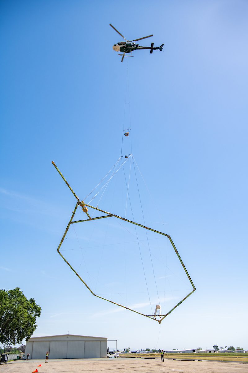
AEM surveys are comparable to an MRI of the earth. They use helicopters carrying specialized equipment to scan the subsurface down to 1,000 feet. This helps visualize underground aquifer structures, providing essential information previously unavailable. The survey collected close to 16,000 miles of data, now publicly available, to support California’s water resilience.
This data is crucial for groundwater sustainability agencies (GSAs) to pinpoint optimal areas for groundwater recharge projects. These projects can capture excess rainfall and store it underground for later use – a critical element of California’s strategy to combat drought and adapt to climate change.
“AEM data helps GSAs move… towards … projects in areas previously deemed as non-suitable for groundwater recharge,” explained Kassy Chauhan, Executive Officer of the North Kings Groundwater Sustainability Agency. She cites the ability through AEM to see where “the soil conditions are prime for groundwater recharge to occur.”
California’s groundwater basins are vital water sources for millions of residents, especially during droughts. This project provides essential information to manage them sustainably, in alignment with the Sustainable Groundwater Management Act (SGMA).
“Data from these… surveys are already being used by local groundwater agencies,” said Paul Gosselin, Deputy Director of Sustainable Groundwater Management, “and we…are providing new tools for understanding and managing California’s groundwater.”
DWR now begins the “Basin Characterization ” phase. It will incorporate AEM data and other information for the most detailed groundwater mapping ever done in the state, using the latest techniques and a collaborative approach.
To promote accessibility, DWR has also developed online AEM Data Viewers . These interactive tools eliminate the need for specialized software, allowing anyone to explore the data and better understand California’s precious underground water resources.
This work is critical as California faces a future of weather extremes. DWR will continue to update its groundwater conditions reports, integrating the latest data, to support local agencies as they make crucial decisions for sustainability, drought resilience, and flood mitigation.
Image:
The California Department of Water Resources Statewide Airborne Electromagnetic (AEM) Surveys holds an event to learn about AEM surveys, the innovative technology used to conduct them, and how the information gathered supports the implementation of the Sustainable Groundwater Management Act (SGMA). Photo taken April 8, 2022.


Leave a Reply